Thermal cameras capture thermal images that help detect temperature variations, which can be critical for monitoring agricultural health, detecting pollution emissions from industrial plants, and conducting aerial thermography for military purposes. This article highlights the technology’s role in effectively visualizing environmental changes, assessing crop conditions, monitoring natural resources, and ensuring compliance with environmental regulations.
Thanks to Abhishek Deshpande for working with me on this report!
Thermal pictures, often known as thermographs, are a measurement of the heat radiation radiated by the recorded objects. Thermographic cameras can be used to capture these pictures. Thermal radiation in the infrared region is released by all bodies at ambient temperature. As the temperature of the body rises, the wavelength of the produced light lowers, and it begins to emit a faint red glow, gradually increasing to a white-hot glow, indicating that it is radiating the whole visible spectrum. A thermal picture enables us to detect an object’s temperature and compare it to the temperature of the surrounding items in the environment. This temperature difference can also be used to make a detailed map of the environment and monitor the Earth’s land cover.
Thermal cameras are simply devices that capture a thermal image and display it on the screen in one of three scales: An iron palette, a black/white/grey palette, and a rainbow palette. This differs based on the requirement and the type of the camera. The iron palette is the most used palette; the black/white/grey palette can be used to help identify details of an image; and the rainbow palette has the best thermal sensitivity, and it can be used to display the differences in temperature better.
A typical thermal camera consists of the following parts:
- Lens: Focuses infrared energy into the sensor.
- Thermal sensor: It is used to sense the heat from the environment.
- Processing electronics: It is connected to the sensor and is used to process and display the sensor data.
- Mechanical housing: The container for all the parts of the thermal camera.
The thermal sensor itself can be categorised into two types:
- PIR – Passive IR: Detects thermal and black body radiations from bodies. It is the main sensor type used for thermal image capture. For example, a Forward-looking Infrared (FLIR) camera uses a passive IR sensor, which can detect infrared radiations. This is used for aerial scanning and military applications.
- AIR – Active IR: It emits infrared radiations which reflects from the objects and is detected by the receiver. It is generally used in motion sensors.
Working Principle
A Bolometer is a sensor that absorbs thermal radiation and changes resistance as a result of the absorption. This change in resistance can be electrically measured and can be used to determine the incident radiation. This radiation is a function of the object’s temperature, as discussed above, and so can be used to find the temperature of the objects in the sensor’s range. Since a bolometer is a very large sensor, we use an array of micro-bolometers in the thermal camera.
It is important that the thermal camera processor is programmed with some important factors that will help it generate the thermograph:
- Absorption: Different materials absorb varying levels of the different wavelengths of light, affecting the amount of thermal radiation they output.
- Transmission: Some materials transmit certain wavelengths of light, while absorbing others. Other sources of electromagnetic radiation need to be filtered out by the processor of the camera.
- Emission: Depending upon the material of the object, it emits a different amount of thermal radiation. This also needs to be taken into consideration when generating the thermograph.
- Reflectivity: Surface conditions can cause electromagnetic radiation to be reflected off of the subject and into the lens, which would cause the thermal image to be skewed.
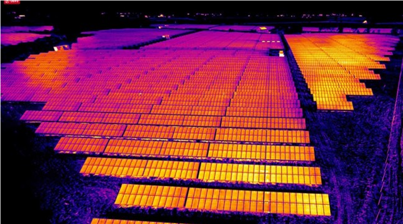
Applications of Infrared Thermography
Infrared cameras see a wide range of applications in the following fields:
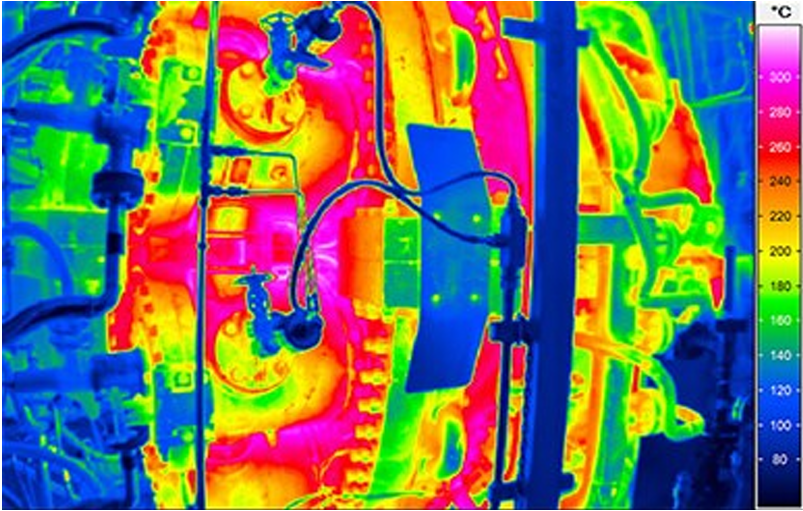
- Automotive and Aerospace: To detect defects and allow reconciliation of thermal properties of components with standard behaviour, and testing active heat flows on composite materials to ensure better standards for next-generation aircraft and ensuring better safety.
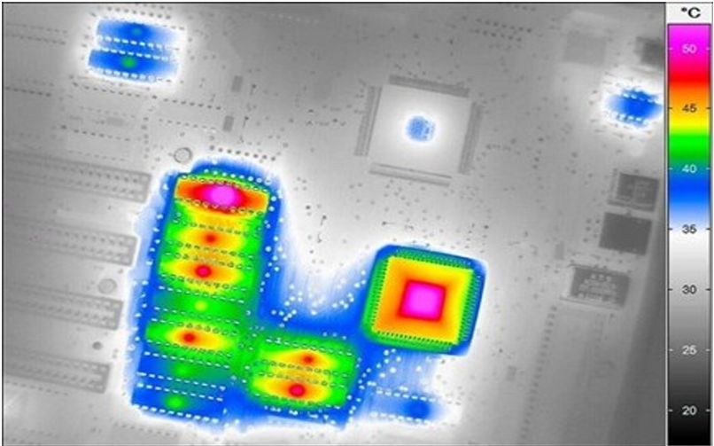
- Electrical and Electronics: To prevent humans from having direct contact with the systems and circuits and avoid risk at the same time testing and detection can be done without interrupting the flow of power, for monitoring overheating, process inspections, and assess circuit boards
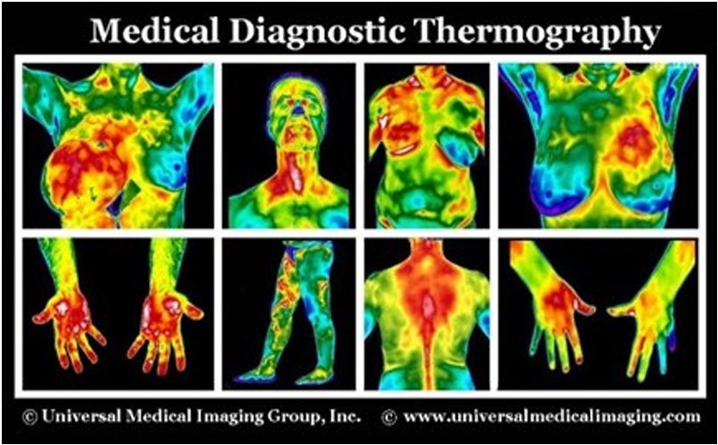
- Medical Imaging: To detect cancer early, monitor circulation issues, and locate sources of arthritis. It can be used by doctors and veterinarians to detect muscular and skeletal problems as well.
- Security: CCTV with a higher range of vision compared to tube-based night vision, to detect people through smoke filled rooms, as well as identify weapons and chemicals
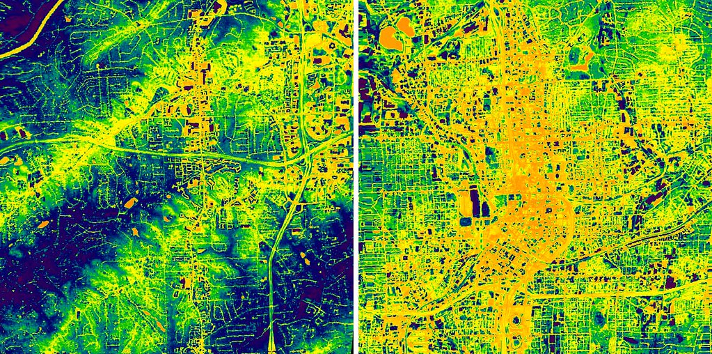
Thermal Imaging in Geomapping
Geomapping is the process of converting raw data from various surveys (Thermal surveys for example) into a visualization of locations of utilities and changes, quickly and accurately. Land and water surveys are carried out using GPS and aerial platforms such as Hybrid LTA (Lighter than air), UAVs or tethered balloons. They present detailed area characteristics such as roads, buildings, mountains, rivers, agricultural areas, etc. Thermal imaging for Geomapping is used thus:
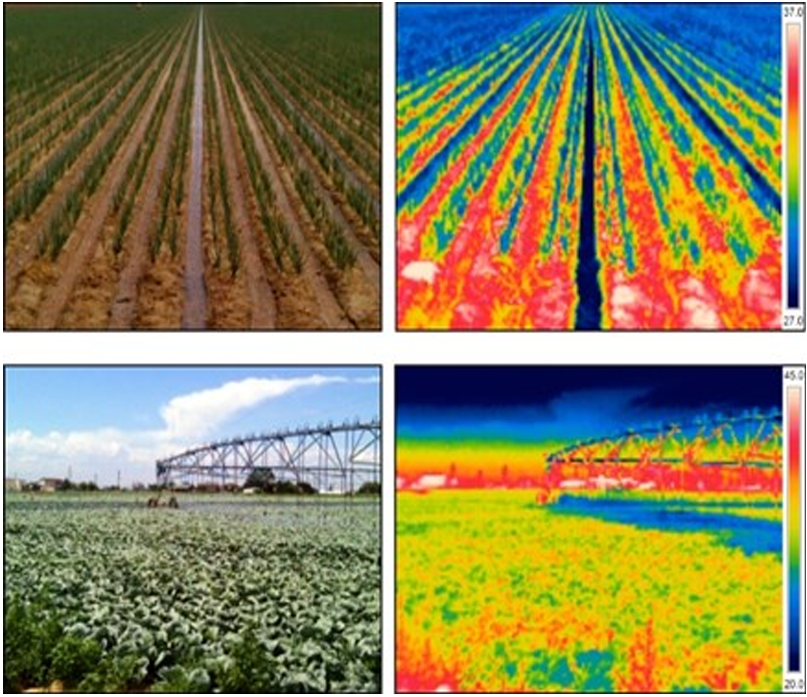
Agricultural Sensing
In thermal remote sensing, the invisible spectral bands are compared to visible images and conclusions are drawn based on the visual-thermal correlation. This helps in monitoring where heat is generated/lost in space and time. Potential uses are evaluating maturity of fruits/vegetables, estimating fruit yield, greenhouse monitoring, irrigation scheduling, plant disease detection, and water and fertilizer management.
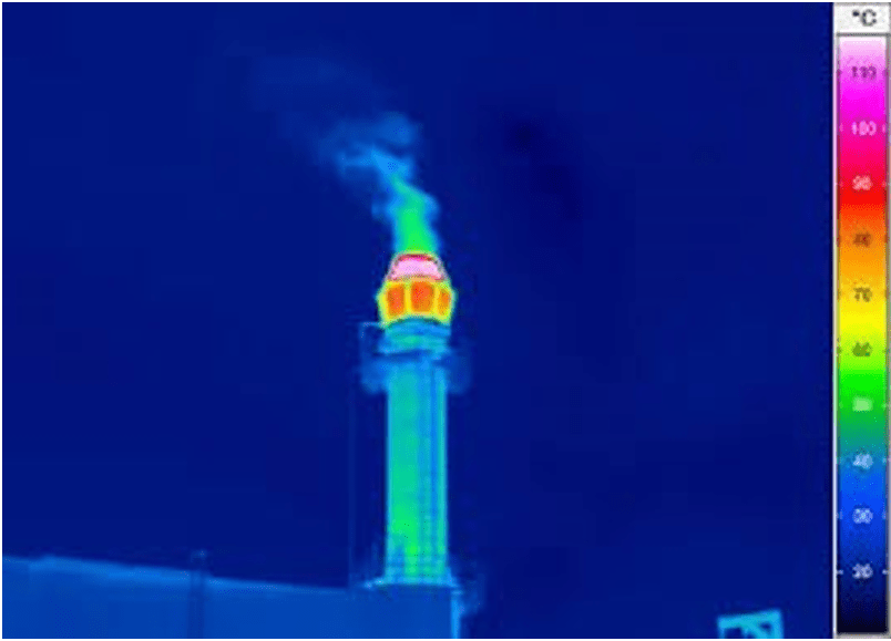
Pollution Detection
Some industrial, pharmaceutical, and petrochemical plants emit gases which might harm the environment, employees, and inhabitants nearby. Environmental protection agencies make sure the emissions are in limit according to government and international policy guidelines by using FLIR optical gas imaging cameras. An optical gas imaging camera is a quick, non-contact measuring instrument that can give the camera operator a quick overview of the leak situation. It can be used in hard to access locations, since it can detect small leaks from several meters away and large leaks from hundreds of meters away. Infrared cameras also help in keeping surface water contamination within limits, since thermal sensors can measure thermal radiations from water with high accuracy and sensitivity. A gradient of thermal readings of land and water surfaces is taken and monitored with IR raw data which can later produce images with visible augmentation of anomalies such as illegal sanitary sewer, discharges and other emissions which are key constituents of pollution.
Aerial Thermography
Aerial thermography has military uses dating back to the Korean War, when it was utilised to locate enemy soldiers and supplies on the ground. Because of the high geometrical resolution employed for observation and monitoring, even the smallest features may be noticed from considerable heights. This type of imaging is used for GPS data and visual images as well as monitoring large geological properties for changes in the landscape or state.
References
- SteveMann, “Basics of Thermal Imaging”, Instructables [Online]. Available: https://www.instructables.com/Basics-of-Thermal-Imaging/.
- “Top Uses and Applications of Thermal Imaging Cameras,” Grainger [Online]. Available: https://www.grainger.com/know-how/equipment-information/kh-thermal-imaging-applications-uses-features-345-qt.
- “How do thermal cameras work?” FLIR [Online]. Available: https://www.flir.in/discover/rd-science/how-do-thermal-cameras-work/.
- “Infrared camera parts,” Sensor BV [Online]. Available: https://www.sensorbv.nl/en/about-us/what-is-thermography/.
- Danny Jost, “What is an IR sensor?” Fierce Electronics [Online]. Available: https://www.fierceelectronics.com/sensors/what-ir-sensor.
- “Basic function of IR thermal camera,” Research Gate [Online]. Available: https://www.researchgate.net/figure/Basic-function-of-IT-thermal-camera-Above-Fig-1-also-shows-the-working-of-the-infrared_fig1_311254439.
- “Application fields of Infrared Thermography,” Tech Imaging [Online]. Available: https://www.techimaging.com/applications/infrared-thermal-imaging-applications.
- “Thermography for automotive and electrical industries,” Infratec [Online]. Available: https://www.infratec.eu/thermography/industries-applications/aerospace-industry/.
- “Role of thermography in electronics,” Azo Optics [Online]. Available: https://www.azooptics.com/Article.aspx?ArticleID=1578.
- “Thermal imaging for medicine,” Universal Medical Imaging [Online]. Available: https://www.universalmedicalimaging.com/thermography.
- “Infrared cameras for security applications,” Infratec [Online]. Available: https://www.infratec.eu/thermography/industries-applications/security/.
- “Geo Mapping” [Online]. Available: https://www.trenchlesspedia.com/definition/3064/geomapping.
- “Remote sensing for evaluating crop water stress at field scale,” Semantic Scholar [Online]. Available: https://www.semanticscholar.org/paper/Remote-sensing-for-evaluating-crop-water-stress-at-Taghvaeian-Ch%C3%A1vez/38cf7b65d11b67ce9241ed7f99aec516506e357c.
- “Thermography in chemical industry,” Infratec [Online]. Available: https://www.infratec.in/thermography/industries-applications/chemical-industry/.
- “Gas emission detection” [Online]. Available: https://www.flir.in/discover/instruments/gas-detection/environmental-protection-with-a-flir-optical-gas-imaging-camera/.
- “How drones are used to inspect renewable energy industry,” DJM Aerial Solutions [Online]. Available: https://djmaerial.com/drone-thermal-inspection-drone-thermography/.

Leave a comment